Centre of the Hungarian County
The remains of the Kovin Fortress are located at a site known as Grad, at the far end of the Danube backwater near the town of Kovin in the Banat region. This mediaeval fortification, constructed between the 11th and 12th centuries, was built atop an earlier Roman castrum. Erected by the Hungarians, the stronghold served to protect the kingdom’s border from attacks by the Bulgarians, Byzantines, and later the Ottoman Empire. The strategic significance of Kovin for the defence of Hungary’s southern frontier led to its development as a county centre and a prosperous urban and trading settlement, frequently referenced in historical documents. Throughout its history, the Kovin Fortress was the site of numerous battles before it was ultimately destroyed following the Treaty of Belgrade in 1739. Today, only a few remnants of the fortress remain, and it has been under state protection since 1995 as an immovable cultural property of great importance.
Due to its exceptionally favourable location, Kovin has been inhabited since the Neolithic Period. Initially, the site of Grad was home to settlements of the Starčevo culture, followed by the Vinča culture. At the beginning of the Bronze Age, around the second millennium BC, an initial defensive fort surrounded by a palisade was constructed, providing its inhabitants with security during times of conflict. From that time onward, encompassing approximately 3,500 years until AD 1739, Grad remained a prominent stronghold along the Danube, changing rulers multiple times.
During the Roman period, the Danube River served as the northern boundary of the Roman Empire, and numerous fortifications were constructed along its banks, collectively known as the Limes. A robust fortress was established at the Grad site in the late 3rd century to secure the most significant river crossing in the region. This is evidenced by coins bearing the likenesses of Roman emperors and bricks stamped with the seal of the 7th Roman Legion (Claudia VII), which was stationed at Viminacium.
ABOVE: Map of the site

ABOVE: Fifteenth-century tower with pilasters
Most researchers agree that this location was the site of the fortress known as Contra Margum (Latin: Contra Margum), as mentioned in historical records. This fortress was situated opposite the castrum of Margum (Latin: Margum) on the right bank of the Danube. Written sources also suggest that the fortress was referred to as Castra Augusto Flaviciusa and Constantin, indicating its service to Emperors Flavius and Constantine.
In the Middle Ages, the Banat region served as a border area of the Kingdom of Hungary—initially against Bulgaria, Byzantium, and Serbia, and later against the Ottoman Empire—resulting in a history marked by numerous border conflicts, wars, and military campaigns. Consequently, every major settlement was fortified as a castrum or castellum. During the initial period, from the late 10th to the late 13th century, county fortresses emerged as military, economic, and religious centres, typically consisting of large-scale wooden-earth fortifications. Four such fortresses were documented in the Banat area, including Kovin. The first mention of Kovin in written records dates to 1073, referring to the fortified town of Castrum Keve. By 1153, it was identified as a fortress and the main settlement of Kovin County under the name Quewen. This fortress likely fell during the Mongol invasion when a part of the Mongol forces crossed the Danube at this location. This assumption is supported by evidence of a significant fire dating to the mid-13th century, after which the settlement was abandoned for an extended period.

ABOVE: The foundation of the tower is currently under archaeological excavation
The intense Ottoman-Hungarian conflicts in the Danube region marked the second phase in the evolution of local military architecture, spanning from the early 14th century to the mid-16th century. As firearms became increasingly prevalent in these confrontations, there was a growing demand for new types of fortifications that differed in both form and scale from those of earlier periods. These fortifications were constructed exclusively from durable materials such as brick and stone.
Under Hungarian rule, Kovin was the oldest Serbian settlement in Banat. The Serbs who settled in Kovin received privileges from King Sigismund of Hungary in 1404 and maintained control of the town until 1428. Following the fall of Smederevo in 1439, after an attack by the sultan’s forces on the Serbian Despotate, Turkish troops launched assaults on border settlements on the Banat side of the Danube. The Ottomans’ destruction of the fortress and the nearby town resulted in the first displacement of Serbs northward within Hungary. For a brief period, the fortress was part of the Despotate. According to historical chronicles, Despot Lazar Đurđević captured Kovin in 1457, but Mihály Szilágyi returned it to Hungarian control in March 1458. In the same year, the Turks burnt, and looted the royal town of Kovin, prompting King Matthias Corvinus to resettle the Serbs from Kovin near the city of Buda.

ABOVE: Remains of the western rampart of the fortress
Kovin’s fortress finally fell under Ottoman rule in 1551, after which it gradually lost its significance. During this period, Kovin served as the seat of a bey within the Timișoara Eyalet. In June 1604, the Hungarian imperial army swept through the area, capturing the fortress of Kovin, which was defended by 800 Ottoman soldiers. A subsequent record from 1626 indicates that the garrison at Kovin consisted of 1,000 cavalrymen and an equal number of infantry.
In the 18th century, following the Austro-Turkish War of 1737–1739, the Ottoman Empire once again expanded its northern borders to the Sava and Danube rivers. Under the Treaty of Belgrade, Austria retained control of the Tamiš Banat region, including the town of Kovin, but was required to demolish and evacuate all fortifications along the Danube that faced the Ottoman Empire. During this period, the Kovin Fortress was destroyed, leaving only its foundations and a few remnants of stone walls that still exist today.


ABOVE LEFT: Loess elevation where the fortress was built
ABOVE RIGHT: A park now occupies the plateau of the main defended part of the fortress
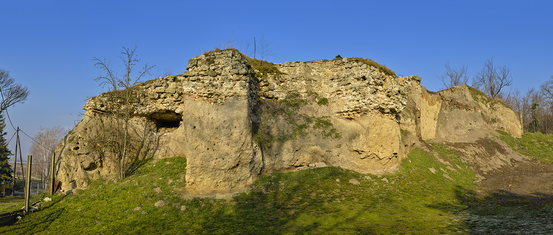
The fortress was constructed on a loess plateau, approximately 8 to 11 meters above the surrounding wetlands. It was accessible only via an elevated ridge from the north, which now forms the urban core of the present-day town. The Danube floodplain bordered the remaining sides of the plateau. Since the stronghold was destroyed in the 18th century, most of our knowledge about its appearance is derived from historical sources. In a 1726 drawing, the Italian Count Marsigli, who mapped the entirety of the Habsburg-Ottoman border as an envoy during the Turkish wars, illustrated the design of the fortress from its final construction phase. According to the sketch, the fortress was built in the Gothic style and consisted of two sections separated by a defensive ditch. The northern, more spacious part of the stronghold covered a rectangular area measuring 150 by 130 meters, with its longer axis orientated northwest to southeast. The entrance to this section of the fort was located at the midpoint of the northern wall, and the remnants of these walls can still be traced along the western and northern edges of the plateau.
Parts of an 11th– to 12th-century necropolis discovered during excavations were arranged around a masonry structure likely used for sacred purposes. Historical records indicate that a church dedicated to the Virgin Mary once existed within the fortress, along with a Franciscan monastery established in the mid-14th century. Today, the site is home to the Stari Grad Hotel and a park featuring a model of the Danube’s course. The southern part of the fortress, which is nearly in ruins, has an irregular triangular layout. The foundations of a 15th-century tower with pilasters and a section of the wall are all that remain. Currently, archaeological work is underway on this tower, while previous protective and exploratory investigations of the entire fortress were conducted in 1968, 1986, and 2003.
List of References
- “Remains of the Fortress.” Information System of Immovable Cultural Heritage.
- Detelić, Mirjana. Epic Cities – Lexicon. Special Editions 84. Belgrade: Institute for Balkan Studies, SASA, 2007.
- Csemere, Zoltán. Fortresses and Fortifications in Banat from the 10th to the 16th Century. Novi Sad: Department of History, Faculty of Philosophy in Novi Sad, 2016.


ABOVE LEFT AND RIGHT: Views of Dunavac, the Danube backwater below the fortress
Al-Idrisi’s Records of Kovin from the Twelfth Century
In 1154, Al-Idrisi, an Arab traveller from Sicily, documented three prominent craft and trade centres in the medieval Hungarian region between the Mureș, Tisza, and Danube rivers: Cenad, Kovin, and Timișoara. Regarding Kovin, he noted that, along with the town of Bač, it ranks among the most urban settlements, featuring numerous beautiful buildings, a large population, a thriving trade primarily based on agricultural products, and many hamlets (manors) associated with the settlement. Al-Idrisi also mentioned that Kovin hosted well-attended fairs and numerous artisan workshops. Archaeological research has confirmed the existence of suburbia close to these fortifications. In the case of Kovin, there is evidence of settlement expansion beyond the city walls, particularly in the latter half of the 12th century.
Photo Gallery
Explore nearby fortresses

Smederevo Fortress

Viminacium